![]()
CORP has prepared the following white paper commenting on the Draft ORP dated May 22, 1999. This white paper is being presented to county supervisors, the press, and other interested parties.
Board of Supervisors
575 Administration Dr.
Santa Rosa, CA 95403
Gentlemen of the Board of Supervisors:
The Coalition for the Outdoor Recreation Plan is an alliance of the county's major outdoor recreation, hiking, riding, trail and conservation organizations, with a combined membership in excess of 15,000 households. Throughout the Outdoor Recreation Plan process, CORP has been the primary voice on behalf of the public's strongly expressed desire for outdoor recreation opportunities. Our mission is "To advocate for an extensive, diverse and sensible system of trails throughout Sonoma County."
The majority of Sonoma County's cities have expressed support for CORP's efforts on behalf of trails, natural parklands, and open space access. Several of these resolutions are attached to this document.
Enclosed are CORP's comments and recommendations on the draft ORP as presented to you by the Citizens' Advisory Committee. These materials are divided into three broad areas:
We are concerned that trails which have been identified by the public in workshops as the county's most desirable alignments have been left off the draft plan, and that proposed trails policies are likely to have the effect of preventing actual acquisition and development of trails. Clearly, this would be counterproductive to the expressed intent of the plan. Policies should facilitate, rather than discourage development of trails.
We appreciate the Board's consideration of these comments and recommendations, and welcome questions regarding our proposed changes to the draft.
Cordially,
Coalition for the Outdoor Recreation Plan
Map of trail
locations in the
August 1998 Draft Outdoor Recreation Plan, plus CORP's proposed
additions to that map. The maps (280 KB) are in Adobe .PDF
format; to download the free Acrobat reader from the Adobe
website, click here: ![]()
Our review of Section VI, "Recommended Policies," of the May 27, 1999 draft of the Outdoor Recreation Plan led us to the following comments and suggestions.
Current language:
Policy 1.3b: Where a trail alignment is not predetermined by a relationship to established publicly owned corridors such as abandoned railroad rights-of-way, flood control channels, or similar facilities, the Board of Supervisors may direct the preparation of a study or plan for the trail, taking into account, costs, a preliminary environmental assessment and any other factors it deems relevant to alignment and feasibility.
Issue/Concern:
This policy could slow or stop implementation of trails due to limited resources (staffing or budget) of the County to prepare a study or plan even though the proposed trail route already exists, but isn't in a publicly owned corridor.
Suggested Revision:
Policy 1.3b: Where a trail alignment is not predetermined by a relationship to existing or historical trail routes, established publicly owned corridors such as abandoned railroad rights-of-way, flood control channels, or similar facilities, the Board of Supervisors may direct the preparation of a study or plan for the trail, taking into account, costs, a preliminary environmental assessment and any other factors it deems relevant to alignment and feasibility.
Current language:
Policy 1.4: The Outdoor Recreation Plan Map . . .
iii) Consider requiring dedication in-fee or by easement for trails as a condition of approval of subdivisions. There must be a need identified on the Outdoor Recreation Plan Map or the project must block an existing access or result in the need for additional recreational opportunities. Locate and fence trails to minimize impacts on agricultural uses.
Issue/Concern:
1) The policy language "...a need identified on the Outdoor Recreation Plan Map..." emphasizes the importance of having a complete trail system illustrated on the ORP Map as well as adding a policy that allows opportunities to add trails when unanticipated opportunities arise.
2) The sentence "Locate and fence trails to minimize impacts on agricultural."
This sentence is (a) not related to the Objective 1.4 or Policy 1.4, (b) sets forth a specific and expensive trail implementation condition, (c) could actually be a negative impact on agricultural operations, (e.g., Bolinas Ridge, where trail fencing could restrict effective grazing patterns), and (d) is already covered under policy 2.1a, using more appropriate language.
Suggested revisions:
1) Add the trails identified in CORP's submittal, 2) add a policy to address the ability to take advantage of unexpected trail opportunities, and 3) strike the last sentence.
Current language:
Policy 2.1b: Prior to developing any new trail route for public use, prepare design and management plans that ensure provision of services necessary to provide for the safety and support of trail users and affected landowners.
Policy 2.1c: Develop design guidelines to ensure trails meet established safety standards and minimize user conflicts. Prior to developing new trail routes for public use, ensure that services and improvements necessary for safety and support of the public using the trail are provided. Such services and improvements should contain, at a minimum, adequate parking and sanitary facilities. Reasonable police and fire protection will be available.
Issues/Concern:
These policies could easily be used to stop implementation of trails by requiring these services and improvements be established when they may be met or addressed in other more cost-effective ways. These issues should be considered but not necessarily required. Reference other local agencies (MROSD, MCOSD, EBRP), that address these issues on a case by case (trail by trail) approach.
Suggested Revision:
Policy 2.1b: Develop design guidelines for trails to address safety issues and minimize user conflicts. Prior to developing any new trail route for public use, consider design and management issues to ensure provision of an appropriate level of service necessary to provide for the safety and support of trail users and affected landowners. Design and management issues to be considered include, at a minimum, police and fire protection.
Current language:
Policy 3.2: Properties acquired in-fee by the County or other agency for outdoor recreation may be land-banked and not open to public use until the park and recreation departments develop master plans and resource management plans pursuant to the California Environmental Quality Act and secure funding for development and operation and maintenance of the properties.
Issue/Concern:
This policy should be more flexible in allowing some public use while plans are being prepared.
Suggested Revision:
Policy 3.2: Properties acquired in-fee by the County or other agency for outdoor recreation may be land-banked and limit public use until the park and recreation departments develop master plans and resource management plans pursuant to the California Environmental Quality Act and secure funding for development and operation and maintenance of the properties.
![]()
In our review of proposed parks and park policy in the May 27, 1999 draft of the Outdoor Recreation Plan, CORP found both good points and serious deficiencies, as described below.
Praise
CORP is encouraged by the following aspects of this draft ORP, as compared to earlier county planning documents.
Concerns
CORP found the following serious shortcomings in the draft ORP with respect to parks and park policy.
"It is recommended that a community inventory its land and water resource base, determine the pattern of these resources, their complexity and suitability for various levels of passive or ecological based leisure pursuits, then address the preservation and protection of such open lands from an environmental as well as a recreation policy driven program."
This critical omission was also noted by Frances Brigmann, in an open letter to CORP dated January 22, 1999 commenting on an earlier draft of the ORP. Ms. Brigmann, the General Manager of the Marin Open Space District and Director of Marin County's parks system (and a Sonoma County resident) asked:
"...where is the material which recognizes the physical features of Sonoma County that are both environmental resources and possibilities for public outdoor recreation facilities (for example, the coastline, the Bay shore, the Russian River, the mountains and ridges)? I believe it is important to highlight what assets Sonoma County has that are, or might become, meaningful opportunities for public outdoor recreation. These physical feature assets are key, as the issue is not providing outdoor recreation just anywhere in Sonoma County. People want to go to specific areas in Sonoma County. These assets then need to be considered together with information on where people live in Sonoma County and what outdoor recreation facilities they want." [See note 1.]
Successful parks and open space districts throughout the Bay Area take stock of where they are, then decide where they want to go in an open process, then plan how to get there. Sonoma County's draft ORP has skipped the first two critical steps. Instead, most of the justifications given for proposed parks in the "Recommendations" section are limited to grandfathering from earlier plans and expressions of support at a single workshop. This results in an unacceptably haphazard process for selecting proposed parks.
- County and regional parks in general are intended to serve nearby populations. Sonoma County is large enough that we must look at whether individual areas are being underserved, particularly for the types of parkland the public overwhelmingly wants more of. Quantitative analysis of some kind is needed if our goals include addressing underserved areas of the county, as CORP believes they must. [See note 3.]
- County residents need to see how we have fared against the quantitative goals used in past plans, which are listed on page 36 of the draft ORP. Sonoma County's regional park acreage currently stands at less than half the goal of 20 acres per 1000 population proclaimed in the 1979 and 1989 General Plans. CORP's analysis shows that, even if all the proposed parklands in this draft ORP are acquired, we will still fall short of that goal and will remain in the bottom tier of Bay Area counties in terms of local parkland per capita. [See note 4.]
For the same reasons, we would like a more ambitious stance in favor of new and expanded parks from non-county jurisdictions. Objective 3.1 and policy 3.1 do refer to interagency cooperation, but in a very general way. The only specific mention of a new state park is at Willow Creek (1000+ acres) near Monte Rio. Why are there not more new state parks, or significant expansions of Jack London, Sugarloaf, Austin Creek, Annadel, Fort Ross, etc.? Why not a national park in Sonoma County? It is true that recent decades have not been kind to state and national parkland acquisition, but there are many indications the climate may be changing for the better both in Sacramento and Washington D.C. It is high time to put Sonoma County on the planning horizon for state and national parks.
Quite properly, there is no provision in the stated process giving veto authority to current landowners who don't want parks or trails in their vicinity. Such landowners are free to choose not to sell their own land, but they should not be able to infringe on the rights of their current and future neighbors by sabotaging the planning process. Backroom power politics are not supposed to part of the process for siting parks and trails in this plan.
Yet the draft ORP has made a number of recommendations and has undergone a number of changes which cannot be explained in any other way. The case of the trail over Sonoma Mountain from the Petaluma Adobe to Jack London Park is the most glaring example. This trail was given the absolute highest score in the 1997 "needs evaluation," (Appendix 2d) and has consistently been the top trail requested by the public. Yet it mysteriously disappeared from draft ORP maps about a year ago, and is replaced in the current map by the "Petaluma to South Sonoma Mountain Trail," which inexplicably avoids the upper part of the mountain, connects to nothing, and ends nowhere.
As with trails, so with parks. In the 1989 general plan "Schematic Map of Designated Outdoor Recreation Areas", there are four proposed park symbols clustered around the summit of Sonoma Mountain. What became of these proposed parks in the 1999 draft ORP?
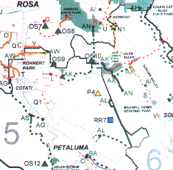
- One of these parks, shown at the location of Petaluma's Lafferty Ranch Park, has morphed into "Lafferty Ranch Preserve" (P4 on the "After" map, below). The ORP's definition of "preserve" suggests more limited public access than that described in Petaluma's management plan.
- A second, formerly on the southeastern side of Crane Creek Regional Park toward Sonoma Mountain, where it would have helped complete the proposed trail (AK) to Jack London Park, is now called the "Crane Creek Regional Park Expansion" (OS9) and has moved to the northwestern, downhill, side of the park -- away from Sonoma Mountain.
- A third, near the location of the Fairfield Osborne Preserve (which currently permits very limited public access) has disappeared without a trace.
- A fourth, closest to the summit and Jack London State Historic Park, is now unveiled as the "North Sonoma Mountain Park" (OS10), an 85-acre Regional Open Space Park. Eighty-five acres! And this despite the fact that this Regional Open Space category is supposed to be reserved for large parks of 300+ acres. [See note 5.]
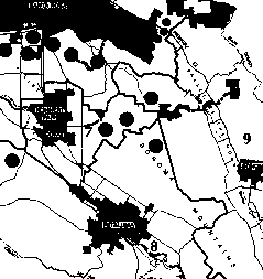
Before: Close-up of Sonoma Mountain area from 1989 General Plan, "Schematic Map of Designated Outdoor Recreation Areas," Figure OS-4a. Dark circles are (schematic) proposed parks.
After: Close-up of Sonoma Mountain area from 1999 Draft Outdoor Recreation Plan, page 107. Dark triangles are proposed Regional Open Space Parks, light triangles are proposed Regional Preserves, and dark squares are proposed Regional Recreation Areas.
On what basis were these decisions made to move, delete, and truncate parks and trails on upper Sonoma Mountain? The facilities described in the current draft weren't grandfathered from previous plans, as such, and they certainly weren't requested in this form by the public. On the contrary, the top priority for south county residents is to "acquire and develop facilities on Sonoma Mountain as accessible open space" (page 72).
It is difficult to escape the conclusion that the ORP process has been unduly influenced by special interests with an agenda of keeping trails and parklands off the upper slopes and ridges of Sonoma Mountain. This is contrary to the open process espoused in the plan, and the people of Sonoma County deserve better.
Recommendations
CORP recommends that the park siting provisions of the Draft ORP be amended as follows:
Note 1. The complete Brigmann letter, along with related documents, can be seen on the CORP website at http://www.sonomatrails.org/docs/brigmann.htm
Note 2. Sonoma County needs a vision to guide its parkland acquisition, and as visions go, the Marin and Midpeninsula visions of acquiring upland greenbelt near cities is a very good one. As public open space, such ridges and uplands deliver an unmatched set of public, economic, and environmental benefits, as seen in parts of the South and East Bay as well as in Marin:
- extensive trail-oriented recreation close to home;
- spectacular two-way views (of the ridges from the populated valleys and vice versa);
- wildlife habitat and corridors;
- convenient opportunities for nature study and education;
- natural watershed;
- urban separators.
Such benefits, as has been amply documented, pay significant dividends (see the website of the Trust for Public Land, http://www.tpl.org for more on the economic benefits of parklands and open space):
- for the health of residents, through salutary outdoor exercise and stress reduction;
- for the health of the economy, by increasing the region's appeal to visitors, employers, and high-demand employees through viewshed preservation and outdoor recreation opportunities; and
- for the health of the environment, both directly through habitat and watershed protection and indirectly through public education about, and stewardship of, nature.
Our Sonoma County cities, while not necessarily bounded by ridges on all sides, all have suitable upland greenbelt nearby.
Note 3. Based on statistics in the draft ORP itself, the southern third of Sonoma County is clearly the most underserved in terms of parkland of all jurisdictions.
The draft ORP divides the county into 6 "park planning areas," of which areas 5 and 6 correspond roughly with Supervisorial districts 2 and 1, respectively. Area 5 includes the Petaluma Valley plus Cotati and Rohnert Park, with a 1995 population of 111,200. Area 6 includes the Sonoma Valley, with a population of 38,500. Taken together, areas 5 and 6 have 36% of the county's population.
Areas 5 and 6 have the fewest acres of publicly accessible open space in the County, by a very wide margin, with only 1147 acres of state and county parkland combined, less than 3% of the county-wide total of 44,555 acres. Three percent of the parklands for 36% of the population!
It is not as though the region is devoid of natural beauty and suitable greenbelt. Residents of the Sonoma and Petaluma Valleys and the southern Santa Rosa plain look up every day at the region's most prominent landform, Sonoma Mountain, the upper reaches of which are still largely undeveloped. It is difficult to imagine a more obvious site for large open space parks in the southern half of the county than upper Sonoma Mountain, yet the ORP drafters seem to have overlooked it.
For more analysis of parkland distribution within Sonoma County, see the following documents on the CORP website:
http://www.sonomatrails.org/docs/orpparks.htm
http://www.sonomatrails.org/docs/drvtime.htmNote 4. According to the draft ORP, Sonoma County currently has 3,503.1 acres of Open Space Parks (Passive), plus 622.2 acres of Regional Recreation Areas (Active), for a total of 4125.3 acres of what were formerly called simply "Regional Parks." Using the 1998 County population of 418,100, we have 9.87 acres of Regional Parks per 1000, less than half of the 1979 and 1989 goal of 20 acres of regional park per 1000 population.
We also must take issue with the draft ORP's assertion, on page 36-37 that, "[s]tate and federal lands were counted toward meeting some of this need." The wording of the 1989 General Plan directly contradicts this assertion on page 380:
"Federal Recreation Areas and State Parks provide recreation opportunities intended to serve national or statewide populations. Regional parks provide opportunities for a broad range of recreational activities generally within a 30-60 minute drive from urban areas at a rate of 20 acres per 1,000 persons."
If we meet the parkland acquisition goals in the draft ORP (a big "if," considering many of the proposed parks have languished in previous plans for decades), we would have 9769.3 acres of Regional Parks. That would meet the former NRPA standard with over 23 acres per 1000 assuming the 1998 population. But using the ABAG estimate of our county's population in the year 2010 of 508,200, we again fall just short at 19.22 acres per 1000.
Furthermore, it is important to realize that the 20 acres / 1000 guideline does not describe a "parklands-rich" region by area standards. CORP's analysis of locally administered public open space shows a Bay Area average of 35.7 acres / 1000 population, almost double the fomer NRPA standard and more than three times Sonoma County's current total. See http://www.sonomatrails.org/docs/openclsd.htm
Note 5. In addition, an active-use regional recreational area on the mountain's lower slopes is proposed, called "South Sonoma Mountain Park." Since CORP's focus, and the public's strong preference, is for passive open space and trails, active use parks such as this proposed facility are not considered further here.
![]()