Drive
Time Statistics from Sonoma County's Cities The 1989 Sonoma County General Plan (page 380) states that
The following table measures drive time from Sonoma County cities to its regional parklands. The numbers in the middle of the chart are acres of regional parks. The chart shows, for example, that from Cotati you can reach 1,375 acres of regional parks with a 30 minute drive or less. From Petaluma, only 368. Acres are cumulative: that is, the parks you can reach with a 45 minute drive includes all that you can reach with a 30 minute drive, plus (usually) a few additional parks.
Sonoma County Regional Parks total 4,367 acres. Using the County's 1997 population of 428,609 that comes out to 10.19 acres of Regional Parks per 1,000 persons. Note that a few of these parks on the northern coast are more than a 60 minute drive from all the population centers, however.
Drive
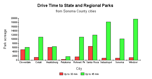
Time Statistics from Sonoma County's Cities This similar table factors in the over 30,000 acres of our State Parks within Sonoma County.
Here is a presentation of most of the above data in graphical form. It shows the proximity of parkland acreage to Sonoma County's cities. Red bars represent the number of park acres accessible with a 30-minute drive. Green bars represent the number of park acres accessible with a 45-minute drive.
Drive time estimates were derived using Mapquest!, from the city center to the main park entrance. Park acreage is from Sonoma County Regional Parks and California State Parks and excludes parks with less than 100 acres of natural open space. See also our raw drivetime estimates upon which these tables were based. |