Proposed
Parks on Sonoma Mountain Tracked Through
Successive County Planning Documents
The Sonoma County Outdoor Recreation Plan, as
of this writing (August 2003) still in draft form, had two major
predecessor planning document: the 1964 Recreation Plan (called
"Recreation Plan 1985" referring to its planning
horizon), and the 1989 General Plan, with its supporting EIR. The
following table compares proposed parks on Sonoma Mountain in the
those two precedessor plans to two drafts of the Outdoor Rec Plan
(ORP):
| 1964 Recreation Plan______ |
1989 General Plan__________ |
1999 Draft ORP____________ |
2003 Draft
ORP__________ |
Lafferty Ranch
Park, 270
acres, described as a
regional attraction. A
"Forest and Wilderness
Park," the category with
the highest priority for
acquisition. |
South Sonoma
Mountain
Park, 200 acres, a proposed
County park of regional
significance shown at
the site of Lafferty Ranch,
ranging from 1000' to 2200'
at the ridgetop. |
Downgraded to Lafferty
Ranch Preserve, suggesting
more limited public access
than that described in
Petaluma's management
plan. Also South Sonoma
Mountain Park, a 300-acre
active-use park sited below
the 1000' level almost five
miles from the summit. |
Shown as Sonoma
Mtn.
Preserve (Lafferty Ranch)
(P12) in a category of "State,
Federal, or Other Parks &
Preserves Consistent with
General Plan or Amendments"
South Sonoma Mtn. Park is
renamed (in some places, but
not others) South County
Regional Park (R11), a 700-
acre (!) active-use "north of
116 and east of Adobe Road."
The county now seems to be
pushing to locate this park
well SOUTH of 116, where no
park has ever been proposed. |
| |
Crane Creek
Expansion,
100 acres, shown on the
southeastern side of Crane
Creek Regional Park toward
Sonoma Mountain and
above 1000', where it would
help complete a newly
proposed trail (AK) to
Jack London State Park. |
Crane Creek
Regional Park
Expansion (OS9), 300 acres,
moved to the northwestern,
downhill, side of the park --
away from Sonoma
Mountain and onto the
valley floor. |
Crane Creek
Regional Park
Expansion (OS11), same
as in the 1999 draft. |
| |
Copeland Creek
Park,
150 acres, shown near
Fairfield Osborne
Preserve (which
currently permits very
limited public access)
at around the 1500' level. |
(Disappeared without
a trace) |
Copeland Creek
Regional
Park (OS16) was reinstated
in response to CORP's input.
Described as 500 acres on the
Northwest slope of Sonoma
Mountain. |
Cooper's Grove
Park, 500
acres from around 2000' to
the summit, northeast of
Jack London Park. A
"Forest and Wilderness
Park," the category with
the highest priority for
acquisition. |
Cooper's Grove
Expansion,
100 acres (not clear what
was to be "expanded"). Same
location. |
North Sonoma
Mountain Park
(OS10), an 85-acre Regional
Open Space Park at the same
location. This despite the
fact that this Regional Open
Space category is supposed
to be reserved for large parks
of 300+ acres. |
North Sonoma
Mountain
Regional Park (OS14), same
as in the 1999 draft. |
| |
East Sonoma
Mountain Park,
shown on the ridge between
upper Carriger canyon and the
Sonoma Valley south of the
Sonoma Developmental Center.
No acreage is given, but likely
parcels in the vicinity are about
200 acres. |
(Disappeared without
a trace) |
(Not yet reinstated
despited
input from CORP. There was
a so-far unsuccessful attempt
to create a trail in the
vicinity, and the State has
added parkland nearby, but
the county is proposing to
do nothing.) |
Total 1964
proposed park
acreage on upper Sonoma
Mountain (1000'+):
770 acres |
Total 1989
proposed park
acreage on upper Sonoma
Mountain (1000'+):
750 acres |
Total 1999
proposed park
acreage on upper Sonoma
Mountain (1000'+):
85 acres |
Total 2003
proposed park
acreage on upper Sonoma
Mountain (1000'+):
585 acres |
While the total proposed parkland acreage in the Outdoor
Recreation Plan has been increasing in subsequent drafts, in
large part due to CORP's persistent advocacy, the above table
shows that acreage has been moving away
from upper Sonoma Mountain.
Besides being our county's namesake, Sonoma Mountain is the
most prominent landform in the souther part of the county, close
to urban centers, but still with large tracts of highly scenic
wildland, with a broad variety of vegetation and wildlife. It is
also rich in historical and cultural significance, with strong
connections to such prominent historical figures as Jack London
and Mariano Vallejo.
CORP believes upper Sonoma Mountain should be an obvious focus
of large-scale parkland aquisition in Sonoma County. For an
Outdoor Recreation Plan which promotes itself as "extensive
and expansive" to propose LESS acreage on the upper mountain
than past plans is unacceptable.
Sonoma Mountain's peaks, ridges, and higher canyons should be
high-priority candidates for open space parkland. The upper part
of the mountain is quite broad, with over 20,000 acres above 1000
feet in elevation, and at least 4000 acres above the 2000-foot
contour. There are still several very large parcels on the upper
mountain (1000+ acres) and many moderately large parcels (200-1000
acres), making large-scale parkland acquisition feasible. But for
how much longer?
Below is a comparison of the maps showing proposed park
designators from the 1989 General Plan (left) and the current
Draft ORP (right).
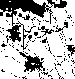 |
 |
Before:
Close-up of Sonoma Mountain area from 1989 General
Plan, "Schematic Map of Designated Outdoor
Recreation Areas," Figure OS-4a. Dark circles
are (schematic) proposed parks. This map is missing
the East Sonoma Mtn. Park, which appears on the Open
Space Plan Map (9), Sonoma Valley, Figure OS-5i.
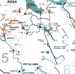
|
After: Close-up of Sonoma
Mountain area from 1999 Draft Outdoor Recreation
Plan, page 107. Dark triangles are proposed Regional
Open Space Parks, light triangles are proposed
Regional Preserves, and dark squares are proposed
Regional Recreation Areas. The 2003 draft ORP is
similar, but another triangle was added (at CORP's
urging) for Copeland Creek Regional Park near the
trail designation "AK".
|
At times, when CORP has asked about the missing
or moved park designators, Regional Parks staff have told us that
prior planners had a particular parcel in mind, and it no longer
seems feasible (subdivided, antagonistic landowner, etc.).
But all General Plan and ORP maps bear the
disclaimer, "Planned future park (Depicts location generally
where parkland is needed.)"
That language makes it clear the proposed park
designators are not supposed to be parcel-specific. So we say, if
not that parcel, then find another nearby-- but leave them in the
plan, and leave them on the upper mountain! Surely the need for
parkland in the "location generally" (which we would
take to be one side or another of upper Sonoma Mountain, in the
case of these parks) is greater than ever, in view of increasing
population and urbanization!
SOURCES: The entire Sonoma
County General Plan (1989) can be found online at the CERES site ( http://elib.cs.berkeley.edu/cgi-bin/doc_home?elib_id=719 ) The Open Space Element maps that accompany this
general plan can be seen at this CERES page ( http://elib.cs.berkeley.edu/docs/data/0700/719/MAPS/index.html ), toward the bottom. Copies of the draft Outdoor
Recreation Plan are available at http://www.sonoma-county.org/parks/outdrpln.htm The 1964 plan is available in some Sonoma County
libraries.
