Proposed Sonoma County
Parklands Compiled by the
Coalition for the Outdoor Recreation Plan (CORP), As of October 1999, County staff preparing the Draft ORP have been directed to continue using the existing standard of 20 acres per 1000 population for park planning purposes. There has been some uncertainty as to which park categories should county toward this goal. In the 1989 General Plan, the 20 acres/1000 standard was apparently applied to the County's Regional Parks, alone. [See note 1.] The following table shows how the various park planning areas would match up against this standard if all proposed County parks (including both "Regional Recreation Areas, Active" and "Regional Open Space, Passive") are implemented by the year 2010. Distribution of County Parklands in 1999 Draft ORP
The following table shows how the various park planning areas would match up against the 20 acres/1000 standard if both State and County parks are implemented by the year 2010 as proposed in the 1999 Draft ORP, and are applied against the standard. Distribution of State and County Parklands in 1999 Draft ORP
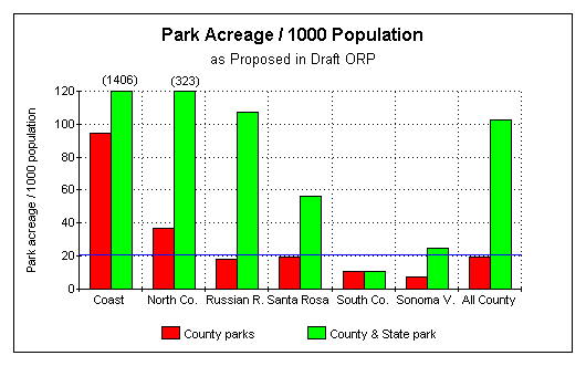
Note that the southern planning areas, the Petaluma and Sonoma Valleys, lag behind the rest of the county by a wide margin. The Petaluma/Cotati/Rohnert Park area, in particular, falls far short of the 20 acres/1000 standard regardless of whether State parks are included. The following chart highlights some of the above data. The blue line is the goal of 20 parkland acres per 1000 population. If all proposed parks in the Draft ORP are implmented by the year 2010, the south county regions are most still most seriously underserved.
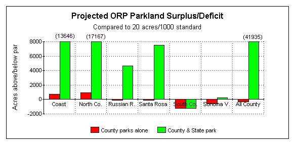
The following chart shows how many park acres each region would have above or below the standard of 20 acres / 1000 population, assuming full implementation of the parks proposed in the Draft ORP by the year 2010.
|