Does
"open space" mean "open to the
public"? Compiled by the
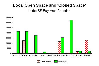
Coalition for the Outdoor Recreation Plan (CORP), While government agencies tend to use a broader definition of the term "open space," CORP believes the public in our county and region expects that its publicly funded open space will be open for public use and enjoyment, not simply "open" in the sense of undeveloped. This expectation results from the practices of neighboring counties such as Marin, San Mateo, and Santa Clara, where public agencies with "Open Space District" in their names manage some 50,000 acres of land, nearly all of which is accessible to the public for low-impact, "passive" recreational use such as hiking, biking, equestrian use, nature study, etc., without significant restrictions. "Open space," then is understood to be synonymous with "parklands" (as distinguished from "parks," which suggests a higher level of development for recreational use). We have coined another term, "closed open space," or simply "closed space," to describe land which is visually open in the sense of undeveloped (where development is limited or prohibited, typically through easements) but closed, or signficantly restricted, to public access. In many parts of the region and the country, private non-profit organizations pursue the protection of closed open space, usually by means of easement purchases, either as an end in itself or with the goal of eventually converting it into open space (parklands). Included are such organizations as the Trust for Public Land, Nature Conservancy, Martinez Land Trust, Napa County Land Trust, Coastal Conservancy, Peninsula Open Space Trust, Marin Agricultural Land Trust, and the Sonoma Land Trust. Sonoma County appears unique in the region, and perhaps beyond, in its use of a public agency (the SCAPOSD) to spend significant amounts of public money directly in acquiring "closed space," an activity elsewhere left to the private land trusts. As noted above, this practice is diametrically opposed to that of other Bay Area public agencies with "Open Space District" in their names. The following graph illustrates the results of this unique policy.
The "closed acres" shown represent land or easements owned by local public agencies (excluding Land Trusts) from which public access is barred or significantly restricted. "Open acres" include open space (as defined above) administered by regional, county, or city agencies. In the three other counties showing any signficant closed space (primarily watershed lands with significant restrictions on public access), open space still predominates. Only in Sonoma County does the closed overwhelm the open. (Note that we have considered Mt. Hood Regional Park's 1400 acress as "open" in this analysis despite the fact that it is currently closed for half of each year. The discrepancy would be even more dramatic if we shifted its designation to closed.)
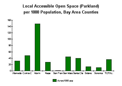
Open Space in Proportion to Population The following table shows locally administered open and closed space for the nine bay area counties, plus demographics.
Sonoma County's 4,367 acres of open space/parklands places it third to last, narrowly ahead of Napa (3,327) County and San Francisco. Viewing parklands as a percentage of total land area would move Sonoma County to dead last, behind even San Francisco. A more common measure is parkland acres per 1000 population. Here Sonoma County ranks second to last, ahead only of tiny and highly urbanized San Francisco County. By this measure, Sonoma County also tallies less than a third of the regional average, and far short of the 20 acres per 1000 population stated in our own general plan.
DATA SOURCES: This analysis by CORP is based on Bay Area Open Space Council data from 1997, updated with information from the websites of the various agencies where available. Please note that while some of the raw data came from the BAOSC, the Council did not perform this analysis and takes no positions on the issues raised here. Refer also to this chart of this data in raw format, which include more information about specific sources. |